Weather Alerts for Alaska
1. Flood Advisory for: Upper Kobuk Valleys
2. Flood Advisory for: Upper Koyukuk Valley
3. Flood Watch for: Kuskokwim Valley West; Kuskokwim Valley East; Northern Bristol Bay Coast; Inland Bristol Bay
4. Flood Watch for: Noatak Valley; Lower Koyukuk Valley; Upper Koyukuk Valley
5. Flood Watch for: South Slopes of the Western Brooks Range; Upper Kobuk Valleys
6. Flood Watch for: Southern Kenai Mtns
7. Flood Watch for: Western Susitna Valley; Southern Susitna Valley; Central Susitna Valley; Northern Susitna Valley
8. Heat Advisory for: Prince of Wales Island; Ketchikan Gateway Borough; City of Hyder; Annette Island
9. High Wind Warning for: Anchorage
10. High Wind Warning for: Anchorage Hillside / Eagle River
11. Hydrologic Outlook for: Anchorage; Anchorage Hillside / Eagle River; East Turnagain Arm; Portage; Lower Matanuska Valley; Hatcher Pass; Sutton / Upper Matanuska Valley; Eureka / Tahneta Pass; Southern Kachemak Bay; SW Kenai Peninsula; NW Kenai Peninsula; Skilak Lake; Southern Kenai Mtns; Interior Kenai Peninsula; Turnagain Pass; West Prince William Sound & Whittier; Tyonek; Valdez; Thompson Pass; Cordova; Western Susitna Valley; Southern Susitna Valley; Central Susitna Valley; Northern Susitna Valley
12. Hydrologic Outlook for: Anchorage; Anchorage Hillside / Eagle River; East Turnagain Arm; Portage; Lower Matanuska Valley; Hatcher Pass; Sutton / Upper Matanuska Valley; Eureka / Tahneta Pass; Southern Kachemak Bay; SW Kenai Peninsula; NW Kenai Peninsula; Skilak Lake; Southern Kenai Mtns; Interior Kenai Peninsula; Turnagain Pass; West Prince William Sound & Whittier; Tyonek; Valdez; Thompson Pass; Cordova; Western Susitna Valley; Southern Susitna Valley; Central Susitna Valley; Northern Susitna Valley
13. Hydrologic Outlook for: Kuskokwim Valley West; Kuskokwim Valley East; Interior Kuskokwim Delta; Western Capes; Northern Bristol Bay Coast; Inland Bristol Bay
14. Hydrologic Outlook for: South Slopes Of The Central Brooks Range; South Slopes of the Western Brooks Range; Noatak Valley; Lower Kobuk Valley; Upper Kobuk Valleys; Lower Koyukuk Valley; Upper Koyukuk Valley
15. Special Weather Statement for: Lower Matanuska Valley
16. Wind Advisory for: Delta Junction
17. Wind Advisory for: Eastern Alaska Range North of Trims Camp; Eastern Alaska Range South of Trims Camp
18. Winter Storm Warning for: Central Arctic Plains; Central Brooks Range
19. Winter Storm Warning for: Western Arctic Plains; Howard Pass and the Delong Mountains
20. Winter Weather Advisory for: Central Beaufort Sea Coast
Want more detail? Get the Complete 7 Day and Night Detailed Forecast!
Current U.S. National Radar--Current
The Current National Weather Radar is shown below with a UTC Time (subtract 5 hours from UTC to get Eastern Time).

National Weather Forecast--Current
The Current National Weather Forecast and National Weather Map are shown below.

National Weather Forecast for Tomorrow
Tomorrow National Weather Forecast and Tomorrow National Weather Map are show below.

North America Water Vapor (Moisture)
This map shows recent moisture content over North America. Bright and colored areas show high moisture (ie, clouds); brown indicates very little moisture present; black indicates no moisture.

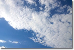
Weather Topic: What are Stratus Clouds?
Home - Education - Cloud Types - Stratus Clouds
 Next Topic: Wall Clouds
Stratus clouds are similar to altostratus clouds, but form at a
lower altitude and are identified by their fog-like appearance, lacking the
distinguishing features of most clouds.
Stratus clouds are wider than most clouds, and their base has a smooth, uniform
look which is lighter in color than a nimbostratus cloud.
The presence of a stratus cloud indicates the possibility of minor precipitation,
such as drizzle, but heavier precipitation does not typically arrive in the form
of a stratus cloud.
Next Topic: Wall Clouds
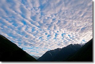
Weather Topic: What are Altocumulus Clouds?
Home - Education - Cloud Types - Altocumulus Clouds
 Next Topic: Altostratus Clouds
Similar to cirrocumulus clouds, altocumulus clouds are
characterized by cloud patches. They are distinguished by larger cloudlets
than cirrocumulus clouds but are still smaller than stratocumulus clouds.
Altocumulus clouds most commonly form in middle altitudes (between 2 and 5 km)
and may resemble, at times, the shape of a flying saucer.
These uncommon formations, called altocumulus lenticularis, are created by uplift
in the atmosphere and are most often seen in close proximity to mountains.
Next Topic: Altostratus Clouds
Current conditions powered by WeatherAPI.com


