Weather Alert in California
Flood Warning issued August 25 at 6:54PM PDT until August 26 at 7:00AM PDT by NWS Phoenix AZ
AREAS AFFECTED: Imperial, CA
DESCRIPTION: * WHAT...Flooding caused by excessive rainfall is expected. * WHERE...A portion of southeast California, including the following county, Imperial. * WHEN...Until 700 AM PDT Tuesday. * IMPACTS...Low-water crossings are inundated with water and may not be passable. Local law enforcement have reported water rescues. * ADDITIONAL DETAILS... - At 653 PM PDT, local law enforcement reported substantial flooding with multiple flooded roadways and water rescues across the Imperial Valley. Flooding is already occurring. Between 1 and 2 inches of rain have fallen. - Some locations that will experience flooding include... El Centro, Brawley, Imperial, Holtville, Westmorland, El Centro Naval Airfield, Alamorio, Seeley and Dixieland. - This includes the following highways... CA Route 78 between mile markers 11 and 20. CA Interstate 8 between mile markers 24 and 33. CA Route 111 between mile markers 10 and 19. CA Route 86 between mile markers 10 and 19. - http://www.weather.gov/safety/flood
INSTRUCTION: Turn around, don't drown when encountering flooded roads. Most flood deaths occur in vehicles. Please report observed flooding to local emergency services or law enforcement and request they pass this information to the National Weather Service when you can do so safely.
Want more detail? Get the Complete 7 Day and Night Detailed Forecast!
Current U.S. National Radar--Current
The Current National Weather Radar is shown below with a UTC Time (subtract 5 hours from UTC to get Eastern Time).

National Weather Forecast--Current
The Current National Weather Forecast and National Weather Map are shown below.

National Weather Forecast for Tomorrow
Tomorrow National Weather Forecast and Tomorrow National Weather Map are show below.

North America Water Vapor (Moisture)
This map shows recent moisture content over North America. Bright and colored areas show high moisture (ie, clouds); brown indicates very little moisture present; black indicates no moisture.

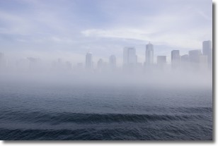
Weather Topic: What is Fog?
Home - Education - Cloud Types - Fog
 Next Topic: Fractus Clouds
Fog is technically a type of stratus cloud, which lies along the
ground and obscures visibility.
It is usually created when humidity in the air condenses into tiny water droplets.
Because of this, some places are more prone to foggy weather, such as regions
close to a body of water.
Fog is similar to mist; both are the appearance of water droplets suspended in
the air, but fog is the term applied to the condition when visibility is less than 1 km.
Next Topic: Fractus Clouds
Weather Topic: What is Freezing Rain?
Home - Education - Precipitation - Freezing Rain
 Next Topic: Graupel
Freezing rain is a condition where precipitation which has fallen in the form of
water droplets reaches temperatures which are below freezing and freezes upon
coming into contact
with surface objects. The result of this precipitation is a glaze of ice which
can be damaging to plants and man-made structures. A severe onset of freezing
rain which results in a very thick glaze of ice is known as an ice storm.
Next Topic: Graupel
Current conditions powered by WeatherAPI.com


