Weather Alert in Alaska
Hydrologic Outlook issued August 30 at 9:40PM AKDT by NWS Fairbanks AK
AREAS AFFECTED: Fairbanks Metro Area
DESCRIPTION: ESFAFG As of 9 PM on Saturday, the Tanana River at Fairbanks has risen to 23.74 feet and water levels are still rising. Flooding impacts are not expected at this time, but those near the Tanana River outside of the dike may observe high groundwater levels. While it is still somewhat uncertain exactly how much the Tanana will rise before cresting and receding, river levels will likely approach 24 feet either tomorrow or Labor Day. At this level, while no specific flood impacts will be realized, bankfull conditions will be noted in the vicinity of Old Richardson Hwy in Salcha, and water may begin to spill over the bank and approach Ruger Trail near Bradbury Road. Tanana River water has a history of beginning to flow into the Piledriver Slough as well when river levels in the Tanana at Fairbanks reach 24 feet. Additional rainfall amounts over the next few days in Fairbanks and upstream areas are expected to remain under a quarter of an inch. As such, any further rainfall this weekend is not expected to bring additional impacts to locations in Fairbanks near the Tanana.
INSTRUCTION: N/A
Want more detail? Get the Complete 7 Day and Night Detailed Forecast!
Current U.S. National Radar--Current
The Current National Weather Radar is shown below with a UTC Time (subtract 5 hours from UTC to get Eastern Time).

National Weather Forecast--Current
The Current National Weather Forecast and National Weather Map are shown below.

National Weather Forecast for Tomorrow
Tomorrow National Weather Forecast and Tomorrow National Weather Map are show below.

North America Water Vapor (Moisture)
This map shows recent moisture content over North America. Bright and colored areas show high moisture (ie, clouds); brown indicates very little moisture present; black indicates no moisture.

Weather Topic: What is Hail?
Home - Education - Precipitation - Hail
 Next Topic: Hole Punch Clouds
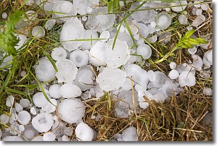
Hail is a form of precipitation which is recognized by large solid balls or
clumps of ice. Hail is created by thunderstorm clouds with strong updrafts of wind.
As the hailstones remain in the updraft, ice is deposited onto them until their
weight becomes heavy enough for them to fall to the earth's surface.
Hail storms can cause significant damage to crops, aircrafts, and man-made structures,
despite the fact that the duration is usually less than ten minutes.
Next Topic: Hole Punch Clouds
Weather Topic: What are Mammatus Clouds?
Home - Education - Cloud Types - Mammatus Clouds
 Next Topic: Nimbostratus Clouds
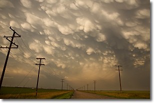
A mammatus cloud is a cloud with a unique feature which resembles
a web of pouches hanging along the base of the cloud.
In the United States, mammatus clouds tend to form in the warmer months, commonly
in the Midwest and eastern regions.
While they usually form at the bottom of a cumulonimbis cloud, they can also form
under altostratus, altocumulus, stratocumulus, and cirrus clouds. Mammatus clouds
warn that severe weather is close.
Next Topic: Nimbostratus Clouds
Current conditions powered by WeatherAPI.com


