Weather Alert in Arizona
Flood Advisory issued September 3 at 3:01PM MST until September 3 at 4:15PM MST by NWS Flagstaff AZ
AREAS AFFECTED: Coconino, AZ
DESCRIPTION: * WHAT...Flooding caused by excessive rainfall is expected along Lake Mary Road, near Mormon Lake. * WHERE...A portion of north central Arizona, including the following county, Coconino. * WHEN...Until 415 PM MST. * IMPACTS...Minor flooding in creeks and normally dry washes is imminent or occurring. * ADDITIONAL DETAILS... - At 300 PM MST, Doppler radar indicated light rain still falling in the area. As much as 3 inches pf rain may have fallen just east of Mormon Lake. Minor flooding is likely ongoing in the advisory area. - This includes the following creeks, washes and rivers... Youngs Canyon, Yellow Jacket Canyon, Anderson Canyon, Padre Canyon, Yaeger Canyon and Walnut Creek. - Some locations that will experience flooding include... Ashurst Lake, Perry Lake, Boot Lake, Mud Lake, Lakeview, Mormon Lake and Upper Lake Mary. - This includes the following recreation areas and campgrounds... Dairy Springs Campground, Ashurst Lake Campgrounds, Pine Grove Campground, Forked Pine Campground and Dairy Springs Campground. - Additional information is available at weather.gov/flagstaff.
INSTRUCTION: Be aware of your surroundings and do not drive on flooded roads. Low water crossings will become dangerous in heavy rain. Do not attempt to cross flooded roads. Find an alternate route.
Want more detail? Get the Complete 7 Day and Night Detailed Forecast!
Current U.S. National Radar--Current
The Current National Weather Radar is shown below with a UTC Time (subtract 5 hours from UTC to get Eastern Time).

National Weather Forecast--Current
The Current National Weather Forecast and National Weather Map are shown below.

National Weather Forecast for Tomorrow
Tomorrow National Weather Forecast and Tomorrow National Weather Map are show below.

North America Water Vapor (Moisture)
This map shows recent moisture content over North America. Bright and colored areas show high moisture (ie, clouds); brown indicates very little moisture present; black indicates no moisture.

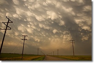
Weather Topic: What are Mammatus Clouds?
Home - Education - Cloud Types - Mammatus Clouds
 Next Topic: Nimbostratus Clouds
A mammatus cloud is a cloud with a unique feature which resembles
a web of pouches hanging along the base of the cloud.
In the United States, mammatus clouds tend to form in the warmer months, commonly
in the Midwest and eastern regions.
While they usually form at the bottom of a cumulonimbis cloud, they can also form
under altostratus, altocumulus, stratocumulus, and cirrus clouds. Mammatus clouds
warn that severe weather is close.
Next Topic: Nimbostratus Clouds
Weather Topic: What is Precipitation?
Home - Education - Precipitation - Precipitation
 Next Topic: Rain
Precipitation can refer to many different forms of water that
may fall from clouds. Precipitation occurs after a cloud has become saturated to
the point where its water particles are more dense than the air below the cloud.
In most cases, precipitation will reach the ground, but it is not uncommon for
precipitation to evaporate before it reaches the earth's surface.
When precipitation evaporates before it contacts the ground it is called Virga.
Graupel, hail, sleet, rain, drizzle, and snow are forms of precipitation, but fog
and mist are not considered precipitation because the water vapor which
constitutes them isn't dense enough to fall to the ground.
Next Topic: Rain
Current conditions powered by WeatherAPI.com


