Weather Alert in Alaska
Flood Watch issued August 30 at 9:21PM AKDT until September 3 at 12:00PM AKDT by NWS Fairbanks AK
AREAS AFFECTED: South Slopes of the Western Brooks Range; Noatak Valley; Upper Kobuk Valleys; Lower Koyukuk Valley; Upper Koyukuk Valley
DESCRIPTION: * WHAT...Flooding caused by last week's excessive rainfall continues to be possible. High river levels are expected to continue into the upcoming week due to additional rainfall amounts of 1 to 3 inches. * WHERE...Including the Noatak, Kobuk, and Koyukuk Rivers. * WHEN...Through Wednesday morning. * IMPACTS...Excessive runoff from last week's rainfall is resulting in flooding of rivers, creeks, streams, and other low-lying and flood-prone locations. * ADDITIONAL DETAILS... - Flooding of roadways has been reported in Kobuk and Allakaket. River levels are also expected to rise above flood stage in Hughes Saturday afternoon. An additional 1 to 2 inches of rainfall is expected Saturday afternoon through Tuesday, which is forecast to prolong high water levels. - Http://www.weather.gov/aprfc
INSTRUCTION: Persons living along streams should stay alert and be prepared to take action if a warning or advisory is issued, or flooding is observed. You should monitor later forecasts and be alert for possible Flood Warnings. Those living in areas prone to flooding should be prepared to take action should flooding develop. Stay tuned to further developments by listening to your local radio, television, or NOAA Weather Radio for further information.
Want more detail? Get the Complete 7 Day and Night Detailed Forecast!
Current U.S. National Radar--Current
The Current National Weather Radar is shown below with a UTC Time (subtract 5 hours from UTC to get Eastern Time).

National Weather Forecast--Current
The Current National Weather Forecast and National Weather Map are shown below.

National Weather Forecast for Tomorrow
Tomorrow National Weather Forecast and Tomorrow National Weather Map are show below.

North America Water Vapor (Moisture)
This map shows recent moisture content over North America. Bright and colored areas show high moisture (ie, clouds); brown indicates very little moisture present; black indicates no moisture.

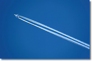
Weather Topic: What are Contrails?
Home - Education - Cloud Types - Contrails
 Next Topic: Cumulonimbus Clouds
A contrail is an artificial cloud, created by the passing of an
aircraft.
Contrails form because water vapor in the exhaust of aircraft engines is suspended
in the air under certain temperatures and humidity conditions. These contrails
are called exhaust contrails.
Another type of contrail can form due to a temporary reduction in air pressure
moving over the plane's surface, causing condensation.
These are called aerodynamic contrails.
When you can see your breath on a cold day, it is also because of condensation.
The reason contrails last longer than the condensation from your breath is
because the water in contrails freezes into ice particles.
Next Topic: Cumulonimbus Clouds
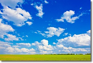
Weather Topic: What are Cumulus Clouds?
Home - Education - Cloud Types - Cumulus Clouds
 Next Topic: Drizzle
Cumulus clouds are fluffy and textured with rounded tops, and
may have flat bottoms. The border of a cumulus cloud
is clearly defined, and can have the appearance of cotton or cauliflower.
Cumulus clouds form at low altitudes (rarely above 2 km) but can grow very tall,
becoming cumulus congestus and possibly the even taller cumulonimbus clouds.
When cumulus clouds become taller, they have a greater chance of producing precipitation.
Next Topic: Drizzle
Current conditions powered by WeatherAPI.com


