Weather Alert in Kansas
Flood Watch issued August 27 at 12:20PM CDT until August 28 at 1:00PM CDT by NWS Wichita KS
AREAS AFFECTED: Ellsworth; Saline; Rice; McPherson; Marion; Chase; Reno; Harvey; Butler; Greenwood; Woodson; Allen; Sedgwick; Elk; Wilson; Neosho; Montgomery; Labette
DESCRIPTION: * WHAT...Flooding caused by excessive rainfall is possible. * WHERE...Portions of Central, South Central, and Southeast Kansas, including the following counties, in Central Kansas, Chase, Ellsworth, Marion, McPherson, Rice and Saline. In South Central Kansas, Butler, Harvey, Reno and Sedgwick. In Southeast Kansas, Allen, Elk, Greenwood, Labette, Montgomery, Neosho, Wilson and Woodson. * WHEN...From 7 PM CDT this evening through early Thursday afternoon. * IMPACTS...Excessive runoff may result in flooding of rivers, creeks, streams, and other low-lying and flood-prone locations. Low-water crossings may be flooded. * ADDITIONAL DETAILS... - A narrow zone of very heavy rainfall is expected to develop overnight into early Thursday morning along a Salina-to- Chanute line. Rainfall totals around 2 to 5 inches are currently being forecast with locally higher amounts possible. Though it has been relatively dry over the past 2 to 3 weeks, this amount of rainfall in a short amount of time could cause areas of localized flooding across the watch area.
INSTRUCTION: You should monitor later forecasts and be alert for possible Flood Warnings. Those living in areas prone to flooding should be prepared to take action should flooding develop. Be especially cautious at night when it is harder to recognize the dangers of flooding.
Want more detail? Get the Complete 7 Day and Night Detailed Forecast!
Current U.S. National Radar--Current
The Current National Weather Radar is shown below with a UTC Time (subtract 5 hours from UTC to get Eastern Time).

National Weather Forecast--Current
The Current National Weather Forecast and National Weather Map are shown below.

National Weather Forecast for Tomorrow
Tomorrow National Weather Forecast and Tomorrow National Weather Map are show below.

North America Water Vapor (Moisture)
This map shows recent moisture content over North America. Bright and colored areas show high moisture (ie, clouds); brown indicates very little moisture present; black indicates no moisture.

Weather Topic: What is Freezing Rain?
Home - Education - Precipitation - Freezing Rain
 Next Topic: Graupel
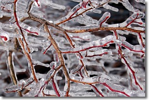
Freezing rain is a condition where precipitation which has fallen in the form of
water droplets reaches temperatures which are below freezing and freezes upon
coming into contact
with surface objects. The result of this precipitation is a glaze of ice which
can be damaging to plants and man-made structures. A severe onset of freezing
rain which results in a very thick glaze of ice is known as an ice storm.
Next Topic: Graupel
Weather Topic: What is Hail?
Home - Education - Precipitation - Hail
 Next Topic: Hole Punch Clouds
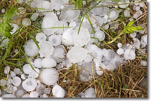
Hail is a form of precipitation which is recognized by large solid balls or
clumps of ice. Hail is created by thunderstorm clouds with strong updrafts of wind.
As the hailstones remain in the updraft, ice is deposited onto them until their
weight becomes heavy enough for them to fall to the earth's surface.
Hail storms can cause significant damage to crops, aircrafts, and man-made structures,
despite the fact that the duration is usually less than ten minutes.
Next Topic: Hole Punch Clouds
Current conditions powered by WeatherAPI.com


