Weather Alert in Hawaii
Coastal Flood Statement issued September 4 at 3:18AM HST until September 7 at 6:00PM HST by NWS Honolulu HI
AREAS AFFECTED: Niihau; Kauai Southwest; Waianae Coast; Oahu North Shore; Olomana; Kahoolawe; Maui Windward West; Maui Leeward West; Kona; Kohala; Kauai North; Kauai East; Kauai South; East Honolulu; Honolulu Metro; Ewa Plain; Koolau Windward; Molokai Windward; Molokai Southeast; Molokai North; Molokai West; Molokai Leeward South; Lanai Windward; Lanai Leeward; Lanai South; Maui Central Valley North; Maui Central Valley South; Windward Haleakala; Kipahulu; South Maui/Upcountry; South Haleakala; Big Island South; Big Island Southeast; Big Island East; Big Island North
DESCRIPTION: ...MINOR COASTAL FLOODING DURING THE HIGH TIDE THROUGH SUNDAY AFTERNOON FOR LOW LYING COASTAL AREAS OF ALL ISLANDS... Peak high tides associated with the lunar cycle will lead to minor coastal flooding along shorelines and low lying coastal areas during the daily afternoon high tide through Sunday. * WHAT...Isolated minor coastal flooding expected. * WHERE...Vulnerable low-lying coastal roadways, docks, boat ramps, and other coastal infrastructure of all Hawaiian Islands. * WHEN...During the afternoon hours at and around the daily peak tides through Sunday. * IMPACTS...Flooding of beaches that are normally dry, minor coastal erosion, and saltwater inundation.
INSTRUCTION: Avoid driving through flooded roadways. If you are forced to drive through salt water, be sure to rinse your vehicle with fresh water. Move electronics, vehicles or other valuables to higher ground. Monitor vessels to ensure mooring lines don't get too tight and watch out for overwash around boat ramps. Secure canoes or other watercraft stowed on beaches.
Want more detail? Get the Complete 7 Day and Night Detailed Forecast!
Current U.S. National Radar--Current
The Current National Weather Radar is shown below with a UTC Time (subtract 5 hours from UTC to get Eastern Time).

National Weather Forecast--Current
The Current National Weather Forecast and National Weather Map are shown below.

National Weather Forecast for Tomorrow
Tomorrow National Weather Forecast and Tomorrow National Weather Map are show below.

North America Water Vapor (Moisture)
This map shows recent moisture content over North America. Bright and colored areas show high moisture (ie, clouds); brown indicates very little moisture present; black indicates no moisture.

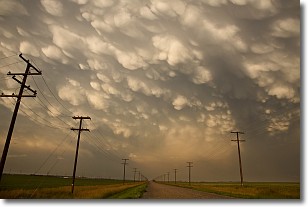
Weather Topic: What are Mammatus Clouds?
Home - Education - Cloud Types - Mammatus Clouds
 Next Topic: Nimbostratus Clouds
A mammatus cloud is a cloud with a unique feature which resembles
a web of pouches hanging along the base of the cloud.
In the United States, mammatus clouds tend to form in the warmer months, commonly
in the Midwest and eastern regions.
While they usually form at the bottom of a cumulonimbis cloud, they can also form
under altostratus, altocumulus, stratocumulus, and cirrus clouds. Mammatus clouds
warn that severe weather is close.
Next Topic: Nimbostratus Clouds
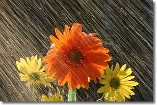
Weather Topic: What is Precipitation?
Home - Education - Precipitation - Precipitation
 Next Topic: Rain
Precipitation can refer to many different forms of water that
may fall from clouds. Precipitation occurs after a cloud has become saturated to
the point where its water particles are more dense than the air below the cloud.
In most cases, precipitation will reach the ground, but it is not uncommon for
precipitation to evaporate before it reaches the earth's surface.
When precipitation evaporates before it contacts the ground it is called Virga.
Graupel, hail, sleet, rain, drizzle, and snow are forms of precipitation, but fog
and mist are not considered precipitation because the water vapor which
constitutes them isn't dense enough to fall to the ground.
Next Topic: Rain
Current conditions powered by WeatherAPI.com


