Weather Alert in Wisconsin
Special Weather Statement issued September 1 at 3:55AM CDT by NWS Milwaukee/Sullivan WI
AREAS AFFECTED: Marquette; Green Lake; Fond Du Lac; Sheboygan; Sauk; Columbia; Dodge; Washington; Ozaukee; Iowa; Dane; Jefferson; Waukesha; Milwaukee; Lafayette; Green; Rock; Walworth; Racine; Kenosha
DESCRIPTION: Pockets of fog are developing across southern Wisconsin early this morning, particularly along and west of the Kettle Moraine. Fog has mainly focused near rivers, creeks, and other low-lying spots, though additional development is possible through daybreak. While localized, brief drops in visibility to and below a mile are possible within pockets of fog. Given the potential for abrupt drops in visibility, budget a few extra minutes of travel time if planning to take to the roads. Use low beam headlights and allow for extra following distance if encountering areas of fog. Conditions will quickly improve following sunrise.
INSTRUCTION: N/A
Want more detail? Get the Complete 7 Day and Night Detailed Forecast!
Current U.S. National Radar--Current
The Current National Weather Radar is shown below with a UTC Time (subtract 5 hours from UTC to get Eastern Time).

National Weather Forecast--Current
The Current National Weather Forecast and National Weather Map are shown below.

National Weather Forecast for Tomorrow
Tomorrow National Weather Forecast and Tomorrow National Weather Map are show below.

North America Water Vapor (Moisture)
This map shows recent moisture content over North America. Bright and colored areas show high moisture (ie, clouds); brown indicates very little moisture present; black indicates no moisture.

Weather Topic: What is Hail?
Home - Education - Precipitation - Hail
 Next Topic: Hole Punch Clouds
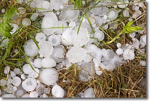
Hail is a form of precipitation which is recognized by large solid balls or
clumps of ice. Hail is created by thunderstorm clouds with strong updrafts of wind.
As the hailstones remain in the updraft, ice is deposited onto them until their
weight becomes heavy enough for them to fall to the earth's surface.
Hail storms can cause significant damage to crops, aircrafts, and man-made structures,
despite the fact that the duration is usually less than ten minutes.
Next Topic: Hole Punch Clouds
Weather Topic: What are Mammatus Clouds?
Home - Education - Cloud Types - Mammatus Clouds
 Next Topic: Nimbostratus Clouds
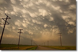
A mammatus cloud is a cloud with a unique feature which resembles
a web of pouches hanging along the base of the cloud.
In the United States, mammatus clouds tend to form in the warmer months, commonly
in the Midwest and eastern regions.
While they usually form at the bottom of a cumulonimbis cloud, they can also form
under altostratus, altocumulus, stratocumulus, and cirrus clouds. Mammatus clouds
warn that severe weather is close.
Next Topic: Nimbostratus Clouds
Current conditions powered by WeatherAPI.com


