Weather Alert in Minnesota
Dense Fog Advisory issued September 13 at 4:31AM CDT until September 13 at 10:00AM CDT by NWS Duluth MN
AREAS AFFECTED: North Itasca; Central St. Louis; Southern Lake/North Shore; Southern Cook/North Shore; North Cass; South Itasca; South Cass; Crow Wing; Northern Aitkin; South Aitkin; Carlton/South St. Louis; Douglas; Bayfield; Ashland; Iron
DESCRIPTION: * WHAT...Visibility one quarter mile or less in dense fog. * WHERE...In Minnesota, Crow Wing, Aitkin, Cass, Itasca, Carlton, South and Central St. Louis, Southern Cook and Southern Lake Counties. In Wisconsin, Ashland, Bayfield, Douglas, and Iron Counties. This includes the Tribal Lands of the Red Cliff Band, the Grand Portage Reservation, the northwestern area of the Lac du Flambeau Band, the Fond du Lac Band, the Bad River Reservation, the Mille Lacs Band, Big Sandy Lake and, East Lake areas and the Bois Forte Band, Lake Vermilion and, Deer Creek areas. Other locations including the Apostle Islands National Lakeshore and Madeline Island. * WHEN...Until 10 AM CDT this morning. * IMPACTS...Low visibility could make driving conditions hazardous.
INSTRUCTION: If driving, slow down, use your low-beam headlights and fog lights, and leave plenty of distance ahead of you.
Want more detail? Get the Complete 7 Day and Night Detailed Forecast!
Current U.S. National Radar--Current
The Current National Weather Radar is shown below with a UTC Time (subtract 5 hours from UTC to get Eastern Time).

National Weather Forecast--Current
The Current National Weather Forecast and National Weather Map are shown below.

National Weather Forecast for Tomorrow
Tomorrow National Weather Forecast and Tomorrow National Weather Map are show below.

North America Water Vapor (Moisture)
This map shows recent moisture content over North America. Bright and colored areas show high moisture (ie, clouds); brown indicates very little moisture present; black indicates no moisture.

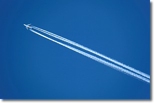
Weather Topic: What are Contrails?
Home - Education - Cloud Types - Contrails
 Next Topic: Cumulonimbus Clouds
A contrail is an artificial cloud, created by the passing of an
aircraft.
Contrails form because water vapor in the exhaust of aircraft engines is suspended
in the air under certain temperatures and humidity conditions. These contrails
are called exhaust contrails.
Another type of contrail can form due to a temporary reduction in air pressure
moving over the plane's surface, causing condensation.
These are called aerodynamic contrails.
When you can see your breath on a cold day, it is also because of condensation.
The reason contrails last longer than the condensation from your breath is
because the water in contrails freezes into ice particles.
Next Topic: Cumulonimbus Clouds
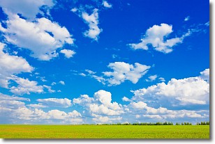
Weather Topic: What are Cumulus Clouds?
Home - Education - Cloud Types - Cumulus Clouds
 Next Topic: Drizzle
Cumulus clouds are fluffy and textured with rounded tops, and
may have flat bottoms. The border of a cumulus cloud
is clearly defined, and can have the appearance of cotton or cauliflower.
Cumulus clouds form at low altitudes (rarely above 2 km) but can grow very tall,
becoming cumulus congestus and possibly the even taller cumulonimbus clouds.
When cumulus clouds become taller, they have a greater chance of producing precipitation.
Next Topic: Drizzle
Current conditions powered by WeatherAPI.com


