Weather Alert in Oklahoma
Flood Warning issued August 28 at 2:28AM CDT until August 29 at 10:00AM CDT by NWS Norman OK
AREAS AFFECTED: Major, OK; Woods, OK; Woodward, OK
DESCRIPTION: ...The National Weather Service in Norman OK has issued a Flood Warning for the following rivers in Oklahoma... Cimarron River near Waynoka affecting Woodward, Major and Woods Counties. * WHAT...Minor flooding is forecast. * WHERE...Cimarron River near Waynoka. * WHEN...From this evening to late tomorrow morning. * IMPACTS...At 8.0 feet, Bankfull conditions exist along the river... and some overflows may occur over some low-lying areas near the river. The river reach affected extends from near Freedom upstream... to the U.S. Highway 281 crossing south of Little Sahara State Park near Waynoka... to near Orienta in Major County. * ADDITIONAL DETAILS... - At 1:30 AM CDT Thursday the stage was 7.4 feet. - Bankfull stage is 8.0 feet. - Forecast...The river will rise above flood stage late this evening to 8.1 feet just after midnight tonight. It will then fall below flood stage late tonight to 6.9 feet early Saturday morning. It will rise to 7.9 feet Monday morning. It will then fall again and remain below flood stage. - Flood stage is 8.0 feet. - http://www.weather.gov/safety/flood
INSTRUCTION: Turn around, don't drown when encountering flooded roads. Most flood deaths occur in vehicles. Be especially cautious at night when it is harder to recognize the dangers of flooding. Additional information is available at www.weather.gov.
Want more detail? Get the Complete 7 Day and Night Detailed Forecast!
Current U.S. National Radar--Current
The Current National Weather Radar is shown below with a UTC Time (subtract 5 hours from UTC to get Eastern Time).

National Weather Forecast--Current
The Current National Weather Forecast and National Weather Map are shown below.

National Weather Forecast for Tomorrow
Tomorrow National Weather Forecast and Tomorrow National Weather Map are show below.

North America Water Vapor (Moisture)
This map shows recent moisture content over North America. Bright and colored areas show high moisture (ie, clouds); brown indicates very little moisture present; black indicates no moisture.

Weather Topic: What are Cumulonimbus Clouds?
Home - Education - Cloud Types - Cumulonimbus Clouds
 Next Topic: Cumulus Clouds
The final form taken by a growing cumulus cloud is the
cumulonimbus cloud, which is very tall and dense.
The tower of a cumulonimbus cloud can soar 23 km into the atmosphere, although
most commonly they stop growing at an altitude of 6 km.
Even small cumulonimbus clouds appear very large in comparison to other cloud types.
They can signal the approach of stormy weather, such as thunderstorms or blizzards.
Next Topic: Cumulus Clouds
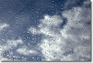
Weather Topic: What is Drizzle?
Home - Education - Precipitation - Drizzle
 Next Topic: Evaporation
Drizzle is precipitation in the form of water droplets which are
smaller than raindrops.
Drizzle is characterized by fine, gently falling droplets and typically does not
impact human habitation in a negative way. The exception to this is freezing drizzle,
a condition where drizzle freezes immediately upon reaching earth's surface.
Freezing drizzle is still less dangerous than freezing rain, but can
potentially result in hazardous road conditions.
Next Topic: Evaporation
Current conditions powered by WeatherAPI.com


