Weather Alert in Washington
Air Quality Alert issued September 2 at 12:45PM PDT by NWS Pendleton OR
AREAS AFFECTED: Kittitas, WA; Yakima, WA
DESCRIPTION: The Washington State Department of Ecology and/or the Yakima Regional Clean Air Agency has issued an Air Quality Alert until further notice. An Air Quality Alert has been issued for Kittitas and Yakima Counties until further notice due to current and expected wildfire smoke from the Wildcat Fire. Particulate matter may reach Unhealthy levels. When air quality is Unhealthy, everyone should reduce exposure. Limit time outside, avoid strenuous outdoor activity, and follow tips for cleaner indoor air. Hot temperatures will increase the risk of heat-related illnesses. Drink plenty of fluids, stay in an air-conditioned room, stay out of the sun, and check up on relatives and neighbors. Information about air quality from the Washington Department of Ecology Web site is available at http://www.ecy.wa.gov/air.html or call 360-407-6000.Information about air quality is on the Yakima Regional Clean Air Agency Web site at http://www.yakimacleanair.org or call 509-834-2050.
INSTRUCTION: N/A
Want more detail? Get the Complete 7 Day and Night Detailed Forecast!
Current U.S. National Radar--Current
The Current National Weather Radar is shown below with a UTC Time (subtract 5 hours from UTC to get Eastern Time).

National Weather Forecast--Current
The Current National Weather Forecast and National Weather Map are shown below.

National Weather Forecast for Tomorrow
Tomorrow National Weather Forecast and Tomorrow National Weather Map are show below.

North America Water Vapor (Moisture)
This map shows recent moisture content over North America. Bright and colored areas show high moisture (ie, clouds); brown indicates very little moisture present; black indicates no moisture.

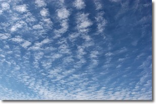
Weather Topic: What are Cirrocumulus Clouds?
Home - Education - Cloud Types - Cirrocumulus Clouds
 Next Topic: Cirrostratus Clouds
Cirrocumulus clouds form at high altitudes (usually around 5 km)
and have distinguishing characteristics displayed in a fine layer of
small cloud patches. These small cloud patches are sometimes referred to as
"cloudlets" in relation to the whole cloud formation.
Cirrocumulus clouds are formed from ice crystals and water droplets. Often, the
water droplets in the cloud freeze into ice crystals and the cloud becomes a
cirrostratus cloud. Because of this common occurrence, cirrocumulus cloud
formations generally pass rapidly.
Next Topic: Cirrostratus Clouds
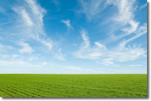
Weather Topic: What are Cirrus Clouds?
Home - Education - Cloud Types - Cirrus Clouds
 Next Topic: Condensation
Cirrus clouds are high-level clouds that occur above 20,000 feet
and are composed mainly of ice crystals.
They are thin and wispy in appearance.
What do they indicate?
They are often the first sign of an approaching storm.
Next Topic: Condensation
Current conditions powered by WeatherAPI.com


