Weather Alert in Oklahoma
Flood Warning issued August 28 at 2:32AM CDT until August 29 at 8:12PM CDT by NWS Tulsa OK
AREAS AFFECTED: Adair, OK; Cherokee, OK; Delaware, OK
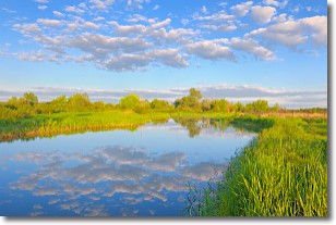
DESCRIPTION: ...The Flood Warning continues for the following rivers in Oklahoma... Illinois River near Watts affecting Delaware and Adair Counties. Illinois River at Chewey affecting Delaware, Cherokee and Adair Counties. Illinois River near Tahlequah affecting Cherokee County. * WHAT...Minor flooding is forecast. * WHERE...Illinois River at Chewey. * WHEN...From Friday afternoon to Friday evening. * IMPACTS...At 12.0 feet, minor flooding occurs from near Fidler's Bend to near Hanging Rock. Road access near the river to residential homes southeast of Chewey Bridge may be compromised. Water begins to impact 630 Road east of the Cherokee/Adair County line. Floating the river is too hazardous due to strong turbulence. * ADDITIONAL DETAILS... - At 2:15 AM CDT Thursday the stage was 3.0 feet. - Forecast...The river is expected to rise above flood stage early Friday afternoon to a crest of 12.1 feet early Friday afternoon. It will then fall below flood stage early Friday afternoon. - Flood stage is 12.0 feet. - http://www.weather.gov/safety/flood
INSTRUCTION: N/A
Want more detail? Get the Complete 7 Day and Night Detailed Forecast!
Current U.S. National Radar--Current
The Current National Weather Radar is shown below with a UTC Time (subtract 5 hours from UTC to get Eastern Time).

National Weather Forecast--Current
The Current National Weather Forecast and National Weather Map are shown below.

National Weather Forecast for Tomorrow
Tomorrow National Weather Forecast and Tomorrow National Weather Map are show below.

North America Water Vapor (Moisture)
This map shows recent moisture content over North America. Bright and colored areas show high moisture (ie, clouds); brown indicates very little moisture present; black indicates no moisture.

Weather Topic: What are Stratocumulus Clouds?
Home - Education - Cloud Types - Stratocumulus Clouds
 Next Topic: Stratus Clouds
Stratocumulus clouds are similar to altocumulus clouds in their
fluffy appearance, but have a slightly darker shade due to their additional mass.
A good way to distinguish the two cloud types is to hold your hand out and measure
the size of an individual cloud; if it is the size of your thumb it is generally
an altocumulus cloud, if it is the size of your hand it is generally a
stratocumulus cloud.
It is uncommon for stratocumulus clouds to produce precipitation, but if they do
it is usually a light rain or snow.
Next Topic: Stratus Clouds
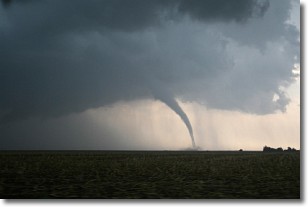
Weather Topic: What are Wall Clouds?
Home - Education - Cloud Types - Wall Clouds
 Next Topic: Altocumulus Clouds
A wall cloud forms underneath the base of a cumulonimbus cloud,
and can be a hotbed for deadly tornadoes.
Wall clouds are formed by air flowing into the cumulonimbus clouds, which can
result in the wall cloud descending from the base of the cumulonimbus cloud, or
rising fractus clouds which join to the base of the storm cloud as the wall cloud
takes shape.
Wall clouds can be very large, and in the Northern Hemisphere they generally
form at the southern edge of cumulonimbus clouds.
Next Topic: Altocumulus Clouds
Current conditions powered by WeatherAPI.com


