Weather Alert in Arizona
Flash Flood Warning issued August 26 at 2:01PM MST until August 26 at 6:00PM MST by NWS Flagstaff AZ
AREAS AFFECTED: Coconino, AZ
DESCRIPTION: FFWFGZ The National Weather Service in Flagstaff has issued a * Flash Flood Warning for... The White Sage in... North Central Coconino County in north central Arizona... * Until 600 PM MST. * At 200 PM MST, Doppler radar indicated thunderstorms producing heavy rain over the White Sage burn scar. Between 1 and 1.5 inches of rain have fallen. Flash flooding is ongoing or expected to begin shortly. HAZARD...Life-threatening flash flooding. Thunderstorms producing flash flooding in and around the White Sage. SOURCE...Radar. IMPACT...Life threatening flash flooding of areas in and around the White Sage. * Some locations that will experience flash flooding include... Condor Viewing Site, House Rock Overlook, House Rock and Le Fevre Overlook. This includes the following creeks, washes and rivers... House Rock Wash, Coyote Wash, Kaibab Wash and Rock Canyon.
INSTRUCTION: Immediately move out of and away from creeks and washes in the White Sage. Flash flooding is occurring or imminent. Turn Around, Don't Drown if you encounter flood waters while driving. Avoid recently burned areas and downstream locations. Life-threatening flooding of creeks, roads and normally dry washes will occur. Rockslides and mudslides will likely occur in steep terrain.
Want more detail? Get the Complete 7 Day and Night Detailed Forecast!
Current U.S. National Radar--Current
The Current National Weather Radar is shown below with a UTC Time (subtract 5 hours from UTC to get Eastern Time).

National Weather Forecast--Current
The Current National Weather Forecast and National Weather Map are shown below.

National Weather Forecast for Tomorrow
Tomorrow National Weather Forecast and Tomorrow National Weather Map are show below.

North America Water Vapor (Moisture)
This map shows recent moisture content over North America. Bright and colored areas show high moisture (ie, clouds); brown indicates very little moisture present; black indicates no moisture.

Weather Topic: What is Sleet?
Home - Education - Precipitation - Sleet
 Next Topic: Snow
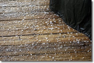
Sleet is a form of precipitation in which small ice pellets are the primary
components. These ice pellets are smaller and more translucent than hailstones,
and harder than graupel. Sleet is caused by specific atmospheric conditions and
therefore typically doesn't last for extended periods of time.
The condition which leads to sleet formation requires a warmer body of air to be
wedged in between two sub-freezing bodies of air. When snow falls through a warmer
layer of air it melts, and as it falls through the next sub-freezing body of air
it freezes again, forming ice pellets known as sleet. In some cases, water
droplets don't have time to freeze before reaching the surface and the result is
freezing rain.
Next Topic: Snow
Weather Topic: What are Stratocumulus Clouds?
Home - Education - Cloud Types - Stratocumulus Clouds
 Next Topic: Stratus Clouds
Stratocumulus clouds are similar to altocumulus clouds in their
fluffy appearance, but have a slightly darker shade due to their additional mass.
A good way to distinguish the two cloud types is to hold your hand out and measure
the size of an individual cloud; if it is the size of your thumb it is generally
an altocumulus cloud, if it is the size of your hand it is generally a
stratocumulus cloud.
It is uncommon for stratocumulus clouds to produce precipitation, but if they do
it is usually a light rain or snow.
Next Topic: Stratus Clouds
Current conditions powered by WeatherAPI.com


