Weather Alert in Alaska
High Wind Warning issued August 27 at 1:11PM AKDT until August 28 at 10:00PM AKDT by NWS Anchorage AK
AREAS AFFECTED: Anchorage Hillside / Eagle River
DESCRIPTION: * WHAT...Southeast winds 35 to 45 mph with gusts up to 70 mph expected. * WHERE...Anchorage Hillside / Eagle River. * WHEN...From 2 AM to 10 PM AKDT Thursday. * IMPACTS...High winds may move loose debris, damage property, and cause power outages. Trees are still fully leafed, and will be particularly vulnerable to damage in strong winds. Travel could be difficult, especially for high profile vehicles. * ADDITIONAL DETAILS...A strong frontal system moving into Southcentral will bring widespread wind gusts ranging from 50 to 70 mph to the Anchorage Hillside beginning early Thursday morning. The strongest winds are expected to peak near the middle of the day on Thursday. Winds will then slowly weaken through Thursday evening and diminish by early Friday morning.
INSTRUCTION: People are urged to secure loose objects that could be blown around or damaged by the wind. Prepare for the possibility of widespread power outages. Use caution if you must drive.
Want more detail? Get the Complete 7 Day and Night Detailed Forecast!
Current U.S. National Radar--Current
The Current National Weather Radar is shown below with a UTC Time (subtract 5 hours from UTC to get Eastern Time).

National Weather Forecast--Current
The Current National Weather Forecast and National Weather Map are shown below.

National Weather Forecast for Tomorrow
Tomorrow National Weather Forecast and Tomorrow National Weather Map are show below.

North America Water Vapor (Moisture)
This map shows recent moisture content over North America. Bright and colored areas show high moisture (ie, clouds); brown indicates very little moisture present; black indicates no moisture.

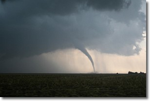
Weather Topic: What are Wall Clouds?
Home - Education - Cloud Types - Wall Clouds
 Next Topic: Altocumulus Clouds
A wall cloud forms underneath the base of a cumulonimbus cloud,
and can be a hotbed for deadly tornadoes.
Wall clouds are formed by air flowing into the cumulonimbus clouds, which can
result in the wall cloud descending from the base of the cumulonimbus cloud, or
rising fractus clouds which join to the base of the storm cloud as the wall cloud
takes shape.
Wall clouds can be very large, and in the Northern Hemisphere they generally
form at the southern edge of cumulonimbus clouds.
Next Topic: Altocumulus Clouds
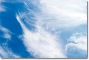
Weather Topic: What are Altostratus Clouds?
Home - Education - Cloud Types - Altostratus Clouds
 Next Topic: Cirrocumulus Clouds
Altostratus clouds form at mid to high-level altitudes
(between 2 and 7 km) and are created by a warm, stable air mass which causes
water vapor
to condense as it rise through the atmosphere. Usually altostratus clouds are
featureless sheets characterized by a uniform color.
In some cases, wind punching through the cloud formation may give it a waved
appearance, called altostratus undulatus. Altostratus clouds
are commonly seen with other cloud formations accompanying them.
Next Topic: Cirrocumulus Clouds
Current conditions powered by WeatherAPI.com


