Weather Alert in Alaska
High Wind Warning issued August 27 at 1:11PM AKDT until August 28 at 10:00PM AKDT by NWS Anchorage AK
AREAS AFFECTED: Anchorage Hillside / Eagle River
DESCRIPTION: * WHAT...Southeast winds 35 to 45 mph with gusts up to 70 mph expected. * WHERE...Anchorage Hillside / Eagle River. * WHEN...From 2 AM to 10 PM AKDT Thursday. * IMPACTS...High winds may move loose debris, damage property, and cause power outages. Trees are still fully leafed, and will be particularly vulnerable to damage in strong winds. Travel could be difficult, especially for high profile vehicles. * ADDITIONAL DETAILS...A strong frontal system moving into Southcentral will bring widespread wind gusts ranging from 50 to 70 mph to the Anchorage Hillside beginning early Thursday morning. The strongest winds are expected to peak near the middle of the day on Thursday. Winds will then slowly weaken through Thursday evening and diminish by early Friday morning.
INSTRUCTION: People are urged to secure loose objects that could be blown around or damaged by the wind. Prepare for the possibility of widespread power outages. Use caution if you must drive.
Want more detail? Get the Complete 7 Day and Night Detailed Forecast!
Current U.S. National Radar--Current
The Current National Weather Radar is shown below with a UTC Time (subtract 5 hours from UTC to get Eastern Time).

National Weather Forecast--Current
The Current National Weather Forecast and National Weather Map are shown below.

National Weather Forecast for Tomorrow
Tomorrow National Weather Forecast and Tomorrow National Weather Map are show below.

North America Water Vapor (Moisture)
This map shows recent moisture content over North America. Bright and colored areas show high moisture (ie, clouds); brown indicates very little moisture present; black indicates no moisture.

Weather Topic: What is Snow?
Home - Education - Precipitation - Snow
 Next Topic: Stratocumulus Clouds
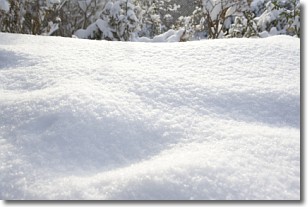
Snow is precipitation taking the form of ice crystals. Each ice crystal, or snowflake,
has unique characteristics, but all of them grow in a hexagonal structure.
Snowfall can last for sustained periods of time and result in significant buildup
of snow on the ground.
On the earth's surface, snow starts out light and powdery, but as it begins to melt
it tends to become more granular, producing small bits of ice which have the consistency of
sand. After several cycles of melting and freezing, snow can become very dense
and ice-like, commonly known as snow pack.
Next Topic: Stratocumulus Clouds
Weather Topic: What are Stratus Clouds?
Home - Education - Cloud Types - Stratus Clouds
 Next Topic: Wall Clouds
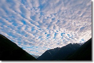
Stratus clouds are similar to altostratus clouds, but form at a
lower altitude and are identified by their fog-like appearance, lacking the
distinguishing features of most clouds.
Stratus clouds are wider than most clouds, and their base has a smooth, uniform
look which is lighter in color than a nimbostratus cloud.
The presence of a stratus cloud indicates the possibility of minor precipitation,
such as drizzle, but heavier precipitation does not typically arrive in the form
of a stratus cloud.
Next Topic: Wall Clouds
Current conditions powered by WeatherAPI.com


